Friday, August 17, 2012
Annapurna Trek part II
After experiencing technical difficulties downloading photos, I'm now posting pictures from the second half of our Annapurna trek. We loved all of the small villages we stayed in...especially Kagbeni (on the road to Upper Mustang and pictured immediately below), Muktinath (a site holy to Hindus and Buddhists) and Thukche (pictured later).
On the way to Upper Mustang...a place we didn't go because traveling there requires a daily visa which is quite expensive. I'm hoping to get there as part of my work. Mustang is one of the 20 districts in Nepal where we are implementing programs.
This monastery is literally just outside our hotel room in Muktinath. However, we didn't get a chance to visit.
Sam, Ben, Lucie and Eli on the roof of our hotel room in Muktinath. We ended up spending quite a bit of time here, acclimatizing, making sure we were all healthy (never happened) and deciding who would try to summit Thorung La pass.
While planning the trek, we realized we didn't have enough time to complete the whole circuit. Most folks move counterclockwise from Pokhara. We decided to go the other way. The challenge was this: going West to East across Thorung La pass is much steeper and more difficult than going East to West. In fact, Thorung La tops out at 17,800 feet (5,416 meters). Originally, all the guys were going to try to make it up but both Sam and Ben were not feeling well. Johnny, my friend's son, had been sick for days and was clearly suffering from altitude sickness. In fact, later, he didn't even remember being in Mukthinath. In the end, it was just me, my brother Brad, my friend Dave and Eli, my 12-year old son.
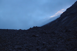
The night before we left Betsy and the kids all migrated back to Kagbeni. Muktinath is about 12,000 feet (and Kagbeni is 9,000 feet). It was good they went back because Johnny really wasn't feeling well. Those of us who planned to summit Thorung La left the hotel at 2:45 a.m. We all had a bowl of dal bhat (lentil soup) before heading out the door. Here is one of the mountains we saw (I believe it is Thorung La itself) some time after it started getting light.
We were doing well on our trek until about 13,500 feet when Eli started feeling sick. It wasn't clear whether he was sick because dal bhat in the middle of the night or because of altitude sickness. He was feeling so bad at 14,000 feet that he decided to turn around. But he first set himself a goal of reaching 15,000. By this point he was really hurting. We reached 15,000 feet and he stopped at an altitude marker that had painted on the side of it "awesome." In my mind, as soon as he stepped foot out the hotel door he was awesome. And here he was at 15,000. He decided to turn around with one of our guides, but not before I snapped a picture of him at the 15,000 foot marker. You could tell he REALLY wanted to make the whole trek. Tears welled up in his eyes--and in mine too. After some deliberation, he decided he'd ascent to 15,500 feet. Pretty soon he was practically skipping along the path.
Getting close!
Now looking westward, the views toward the top of Thorung La were stunning.
This is one of my favorite pictures. I love how nature mimics itself. Here the clouds are in the same formation as the mountains.
Eli at the top. I was so proud of him!

I was proud of my brother too. Brad was REALLY tired but he made it, as did my friend Dave.
One of the two men responsible for getting us to the top (Durga). You couldn't meet a nicer, more dedicated man.
The way back was very tiring. The adrenaline rush was gone. Now came the hardest part. Eli struggled. Toward the end of our hike, one of our guides took Eli's arm to steady him for the last half mile. I commented to Eli that he had a lot more spring in his step when he left the hotel at 2:45 a.m. He replied: "Yes, I think I lost a few springs up there!"
After our successful return...
Thukche was one of our favorite towns. I took this picture at sunset. We were spectators in this drama, a closing act with clouds threatening to end the show, then sunlight on the mountains--a brief glimpse--a last opportunity to see the main attraction. Then like curtains, the clouds began to shut. Then the encore. It was wonderful to see the battle between clouds and sun, light and dark. A colossal display of nature.
On the way down. This is one of my favorite pictures.
One of the challenges of bus travel in the Annapurnas is frequent damage to roads and bridges--largely because of landslides. Here a number of the timbers came loose. Before our bus could pass, we needed to replace the timbers. Needless to say, I wondered if we'd get across the bridge safely.
In addition to taking buses, we also used private jeeps. We weren't certain what "come with pun" meant. The jeeps were safer than the buses but quite crowded and uncomfortable.
Our bus rides were terrifying. At one point, our bus hit a large rock head on and swayed to the right, close to a 45 degree angle. We knew this stretch of road was particularly dangerous when, upon lurching to the right, just short of tumbling down a steep precipice, all the Nepalis gasped loudly. I've been on many dangerous roads--including the one in Bolivia, billed as the most dangerous road in the world (it descends from 15,500 feet to 3,500 feet with drop offs of 3,000 feet), but this road round the west side of the Annapurnas was by far the most terrifying.
The inside of one of our buses. At one point we came face to face with another bus flying around the corner. Dave was at the very front of the bus, next to the front window. The other bus came to a screeching halt 3 feet in front of us.
All in all, it was a wonderful trip. One that none of us will ever forget.
Sunday, August 12, 2012
Annapurna trek
It's been several weeks now since we returned from our Annapurna trek. Unfortunately, I've forgotten many of the trip's details, but I'll offer a few highlights--roughly in chronological order. I may have mis-labeled some of the pictures...at least the mountains. Sorry!
Here we are heading into the Annapurnas. We started in Pokhara on the 26th of June and headed north to Jomosom. It is possible to fly into the Jomosom airport saving 2 days (RT=4 days total), but the landing is notoriously dangerous. So we took the bus (perhaps even MORE dangerous than the plane). More on that later.
There were NINE of us!: Betsy, Sam, Ben, Lucie, Eli, me, my brother Brad, a good friend of mine from Boston (Dave Lazenby) and his son John.
Here are some of the interesting houses on the way to Jomosom. In this picture and several that follow, I'm using my camera's dramatic effect setting to bring out the highlights.
We got to cross a number of bridges, including the one here. Betsy and Lucie in particular liked the bridges. Several sections of the road from Pokhara to Jomosom were washed out so we had to take a jeep or bus from one landslide to the next with different vehicles taking us a bit farther.
I believe this is the spot where the bridge was "out." What that meant in practical terms was that a number of the timbers had popped off of the metal supports. We saw a bus passing in front of us. The bus stopped before reaching the bridge. The driver jumped out and he and several other men placed the timbers back on the bridge. They weren't attached. Amazingly, everything held as the bus crossed the bridge.
This is a picture of my brother Brad at the bottom of a rather massive waterfall. This picture shows a very small part of the waterfall. It was quite a sight!
This is supposed to be the deepest gorge in the world. It's very beautiful but it's definitely not the deepest in the world. I've seen the one that folks claim is the deepest and it's in Peru. The reason Nepalis say this one is the deepest is because they're measuring Daulaghiri (the world's 7th highest mountain) as the top of the gorge when in fact, it's quite a distance from the river.
Just before Jomosom.
One of the first mountains we saw...maybe one of the Nalgiris?
Once we turned the corner from Jomosom, things got VERY dry. In fact, in spite of the fact that we were in the middle of monsoon season, the only rain we got was in Pokhara--the day before we started our trek and again on the day we arrived back.
Toward the end of a hot, dry day, we asked our guide whether tomorrow would be similar to this and he said "no, it will be noticeably drier."
One of my favorite parts of the trip was Kagbeni. We were only in a few towns on this trek. The population is quite sparse in lower Mustang. Every town we stopped in was politically, linguistically and culturally much more closely aligned with Tibet (all restaurants had large pictures of Lhasa) then Nepal.
 |
| Stone alley in Kagbeni |
 |
| My brother Brad at a Stupa in Kagbeni. |
 |
| A couple of children at a monastery in Kagbeni |
 |
| If you look closely, you can see the ball on the left side of the frame. |
This is where we stayed in Kagbeni. Several of the pictures that follow are from our hotel. I like this picture because there is a lot going on...the relatively modern hotel, the man in the middle of the frame, people without identities carrying heavy loads and a steer looking on. I suspect the animal is a cross between a cow and a yak. They were quite common here.
 |
| Another bridge...this one in drier territory |
 |
| Here we are completing a day of hiking in "lush" terrain |
 |
| Kagbeni |

The next 3 pictures are of our porters: Anita, Sarmila and Golpa. I don't have a picture of our guide (Durga). All were wonderful individuals and treated us like family.

Below is a picture of Golden Hill. We were going to climb it on the return trip from Thorung La pass, but by that point, we had little energy. Our guide also indicated that the route up the switchbacks was safe (see right side of picture) but the path up to the top of the mountain (see center/top of photo) was quite dangerous and in several places, you have to be on all fours to cross.
 |
| Lucie somewhere on the trek...looking eerily like Jackie Kennedy Onassis |
 |
| Muktinath. Daulaghiri in the background? |
 |
| Self-portrait in Eli's sunglasses |
Muktinath is sacred to both Hindus and Buddhists. Both believe the waters here spring from Mt. Kailas hundreds of miles away. I'm not sure what the building in the background is but I decided to get a picture of the cairns and the building was a nice backdrop.
Near the river at Muktinath.
One of the 108 fountainheads at Muktinath. These are arranged in a semi-circle and it is possible to run from one fountainhead to the next...though most pilgrims stand under a single head to ritually purify themselves. Betsy and I splashed the cool water on our heads--a little bit from each of the 108 fountains. Given that we were at 12,000 at this point, it's understandable why the water was FREEZING!
Subscribe to:
Comments (Atom)


